

We offer the following trekking expeditions in San Martín de los Andes, from half day soft hikes to more challenging full day trekkings and overnight expeditions camping underneath the starts. All outings include transportation to the start of the trail, certified trekking guide and insurance. For inquiries and bookings please send us an email to info@tierraspatagonicas.com
 Soft hike around this gorgeous lagoon in Lanin National Park, just a few minutes away from San Martín de los Andes. The trail is part of Huella Andina, a net of trails that connect the different national parks of the Andean Patagonia. Along the way we will go through several environments: open areas of transition from steppe to forest with prevalence of shrubs and grasslands, Patagonian forest patches and meadows and aquatic environments in the lagoon and its surrounding areas. The lagoon is one of the best birdwatching spots in the area, so along the way we can watch Patagonia endemic bird species such as Ashy-headed Goose, Black-faced Ibis, Chilean Flicker, Thorn-tailed Rayadito, White-throated Tree-Runner, Chucao Tapaculo, Black-throated Huet-Huet, White-crested Elaenia, Patagonian Sierra-Finch and Fire-eyed Diucon, among many others. If the weather is good we will enjoy a picnic by the lagoon.
Difficulty: easy
Time: 5-hour hike + 1/2 hour transfer
Distance: 8 km / 5 miles
Elevation: minimal
Available: all year long
 A short but challenging trek just a few minutes away from San Martin de los Andes. We will go with the vehicle to the start of the trail, in an area called by the Mapuche native community Pampa del Trompul. Soon we will start going up by the steep slopes covered by dense Patagonian forest. As we gain altitude the vegetation turns shorter which will us to get great views of the Lacár Lake valley. Soon we will pass the timberline and reach a rocky area that will lead us the summit, made of red rocks that are the remains of an old lava flow. From the top, at 1,778 m, we will have a great view of the south face of Lanín volcano, with the Lolog Lake valley on one side and the Lácar Lake valley on the other.
Difficulty: moderate
Time: 5-hour trek + 1-hour transfer
Distance: 9.5 km / 6 miles
Elevation: 850 m / 2,790 feet
Available: November to May
 A short hike up from the Yuco area, on the north shore of Lacar Lake to Las Corinas, two small lagoons hidden in the dense Andean-Patagonian forest. We will drive to Yuco, 30 km away from San Martín de los Andes, leaving the car at the park ranger house. Crossing the road we will find the start of the trail, going up on a steep slope densely covered by southern beeches (Nothofaus obliqua), colihue cane and plenty of fungi, mosses and ferns. Soon we will reach a natural balcony from where we can see Estancia Quechuquina, an old ranch that lived from the pine plantations, and Santa Teresita, a small island near the shore of Lácar Lake. Continuing our way up we will arrive at the first lagoon, Corina Grande, surrounded by tall reeds and algae. Taking a trail to the right we can go down to the second lagoon, Corina Chica, whose water reflects the deep green of the forest. Both the lagoons and the forest around are great areas for birdwatching.
Difficulty: easy
Time: 4 hours
Distance: 6 km / 3.75 miles
Elevation: 300 m / 985 feet
Available: November to May
 Hike in the Valdivian Rainforest to one of the most beautiful and hidden spots of Lanin National Park. We will go with the vehicle from San Martin de los Andes to Hua Hum, on the west end of Lácar Lake. Hua Hum is an old timber settlement that was abandoned when the national park was created. Crossing Hua Hum River we will continue to Queñi Lake, where we will leva the vehicle to start walking by the west side of the lake. Despite some up and downs it is an easy walk. As we progress we will notice how the vegetation turns even denser and the humidity higher; we are entering the Valdivian Rainforest a true “cold jungle” made of enormous Cohiue trees and an extremely rich undergrowth. In about an hour and a half we will leave the lake behind and arrive to Chachín River, which feeds Queñi Lake. Just a few meters more and we will find the thermal springs, with the hot water springing from the rocks to a few natural pools. Do not expect any luxuries here, but taking a thermal bath surrounded by this wild environment is incomparable. After the bath we will have lunch and take our way back to San Martín de los Andes.
Difficulty: easy
Time: 3-hour hike + 3-hour transfer
Distance: 8 km / 5 miles
Elevation: 200 m / 650 feet
Available: November to April
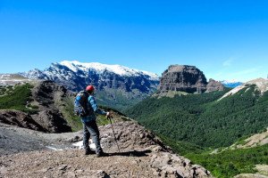
 One of the most traditional climbs in Lanin National Park. Demanding, due to the significant elevation but very rewarding, as the panoramic views from the top are amazing. We will drive from San Martin de los Andes to the strait between lakes Lácar and Nonthué and start walking up through a dense forest of Nothofagus obliqua, which find here the perfect conditions for growing. This is also a good area to find the iconic Magellanic woodpecker. The trail keeps constantly up, with a lot of coihue cane on the sides. After surpassing the 1,000 m altitude the lengas (Nothofagus pumilio) starts to dominate the vegetation cover. Then they start getting shorter and shorter until we surpass the timberline to find an open rocky massif dotted with some small high-andean grasslands. After crossing two water streams we climb on top of the ridge, walking around a crag with some great views of Lanin volcano. After a last rocky slope that is covered by snow almost all year-round we get to the summit, at 1,911 m, with great views of several volcanos, some of them on the Chilean side and of the Lácar, Nonthué and Queñi lakes. The panoramic views from the top are excellent to appreciate the erosion caused by the glacier action on theses Andean valleys.
Difficulty: high
Time: 8-hour trekk + 2-hour transfer
Distance: 16 km / 10 miles
Elevation: 1.230 m / 4,035 feet
Available: November to April
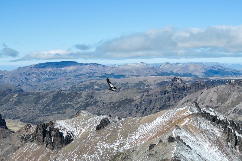 Climb to the second-highest peak of the entire Chapelco massif, one of the best ski resorts in South America. Chapelco is a rocky mountain mass stretching for more than 20 km from San Martin de los Andes to Meliquina Lake. Its rocks have a volcanic origin, with plenty of basaltic rocks that were later carved by the action of the glaciers. We will drive to the base of the ski resort and from there take a forestry trail along the valley that splits Chapelco Grande Peak from the ski resort. We will leave the vehicle by a meadow and start hiking to the southeast by a dense Nothofagus pumilio forest. After passing several high meadows we will arrive at a big one from where see the ridge that we will have to climb. This is the most difficult part of this trek, as we have to overcome a significant slope by a loose rock terrain of a glacial moraine. Once we are over the ridge we are near the summit. On the last stretch the gradient gets softer although it can be really windy up there. Soon we will get to the top, where we will have amazing views of the sharp valley south of Chapelco and all the peaks (most of them volcanos) around, like Lanin, Quetrupillán, Villarrica, Choshuenco, Tronador, Osorno, etc.
Difficulty: high
Time: 8-hour trek + 2-hour transfer
Distance: 12 km / 7.5 miles
Elevation: 1,075 m / 3,525 feet
Available: November to April
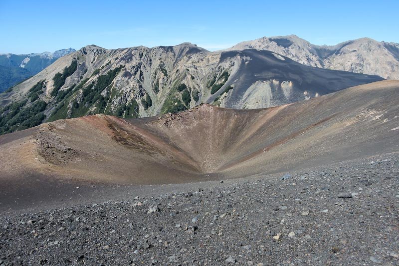
Displaying one of the most striking landscapes in Lanín National Park, Achen Niyeu volcano shows clearly the signs of one of recent volcanism. Its last eruptions, dated around 1,000 years ago, produced a big lava flow that ran into the Epulafquen Lake like a deep black stone river. The area is slowly beginning to be colonized by the forest again, with short lenga trees growing here and there in a long process slowed by the cold climate of the region. To get to the volcano we will drive for 80 km from San Martin de los Andes to Laguna Verde, a small lagoon near Lake Curruhué. We will leave the vehicle there and take the trail to the Auquinco Valley. After going around the lagoon we will start to gain altitude and soon the forest will give way to the volcanic sand and rocks of the Achen Niyeu lava flow. We will make a stop here so we can appreciate the peculiar features of this new volcanic rock. Then we will continue to an open area that leads to Portezuelo de Auquinco, on the north end of the Auquinco River valley. From there we start seeing the rusty red tones of Achen Niyeu Volcano, which is part of the structure of the volcanic massif of Huanquihue, a relatively new volcanic complex. We will start hiking the northeast slope of Achen Niyeu by an almost unnoticeable trail of black and red volcanic sand. On the top, we will have great views of the big crater and of Lanin volcano surrounded by the Andes mountain range.
Difficulty: medium
Time: 5-hour trek + 4-hour transfer
Distance: 11 km / 6.8 miles
Elevation: 650 m / 2,132 feet
Available: November to April
 One of the most attractive peaks on the South part of Lanin National Park, Acol displays magnificent views of lakes Queñi, Nonthué and Lácar and the Chilean mountain range. To get to the start of the trail we will take the course to Hua Hum, on the west end of Nonthué Lake and just a few meters away from the Chilean border. After crossing the Hua Hum River we will take the route to Queñi Lake, where we will leave the vehicle to start our hike. The first part goes through and splendid Raulí (Nothofagus alpina) forest with a dense undergrowth of Colihue Cane. As we gain altitude the Raulí gives way to the Lenga (Nothofagus pumilio), until we reach a viewpoint where we will make a stop. After going around a high meadow we will reach the rocky ground that will take us to the summit, at 1,884 m above sea level. We will have our lunch there while we enjoy the amazing views.
Difficulty: high
Time: 8-hour trek + 3-hour transfer
Distance: 11 km / 6.8 miles
Elevation: 1,280 m / 4,200 feet
Available: November to April
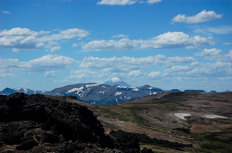
 Stage 8 of Huella Andina, from Puerto Canoa, on Huechulafquen Lake, to the base off Lanín Volcano, the highest peak in the park. Lanín is a symbol of Neuqén province and one of the most attractive moutains in Patagonia. We will go with the vehicle to Huechulafquen Lake, where we will have to pay the park’s entrance fee. Driving around the lake we will get to Puerto Canoa, where we will star hiking. First we will pass by a shrubby pampa and after crossing a river we will enter a forest made of big cohiues, lengas and Araucaria trees. The Araucaria is a conifer that occurs only in north Patagonia, growing on sandy soils, typically of volcanic origin. It can live up to 1,000 years and is considered a relict species, living only in very limited areas. It has an unmistakable shape, with the trunk divided on polygonal plates and, curved braches and hard coriaceous leaves. After crossing several creeks we will star gaining altitude towards the high grasslands. After the last river crossing, we will reach the end of the trail, where we will enjoy a privileged view of the glacier coming down from the south face of Lanin volcano.
Difficulty: Medium / high
Time: 8-hour trek + 4-hour transfer
Distance: 20 km / 12.5 miles
Elevation: 825 m / 2,700 feet
Available: November to April
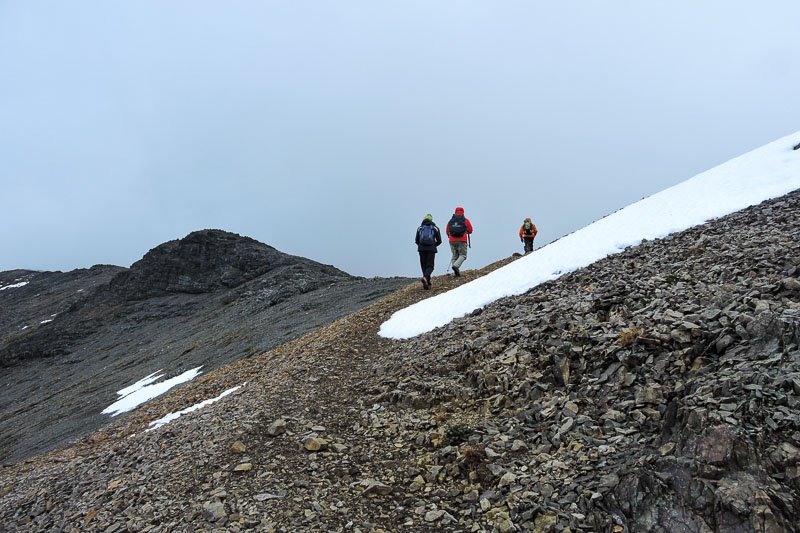
 9-hour trek to the BIM 26 mountain refuge, on the north face route to the Lanin Volcano summit. We will start hiking on the Rubio Turbio area, at 1.100 meters above sea level. After registering at the parks ranger’s office we will start walking through a lenga forest, where we will have the chance to find the Magellanic Woodpecker, one of the most iconic birds of the Patagonian forest. Soon we will reach a clearing made of volcanic rocks from where we will see the volcanic in its entire dimension. The ascent continues by the “fishbone”, an ancient lateral moraine produced by the glaciers that went down the slopes of the volcano during the last ice age. After a 3-hour ascent we will reach the refuge, at 2,300 meters above sea level. There we will have our lunch while we enjoy the magnificent views of the volcano and the Tromen Lake. After lunch we will start descending to the base.
Difficulty: medium/high
Time: 9-hour trekking + 2-hour transfer
Distance: 14 km / 8.7 miles
Elevation: 1.200 m / 3,940 feet
Available: November to April
 A unique experience for those who want to have direct contact with the mountains and the amazing landscapes of Lanin National Park without having to climb big elevations and enjoying two nights camping underneath the stars. The expedition covers stages 12, 13 and 14 of the Huella Andina trail, with sceneries changing all the time from the dense Patagonian forest to the almost lunar landscape of Achen Niyeeu volcano. Forests, blue lakes, mountain rivers, waterfalls, and black sand valleys, all together on the same outing.
It is a 3-day expedition starting in Puerto Arturo, on the northern shore of Lolog Lake, 20 km away from San Martín de los Andes. From there we will go along Lolog Lake heading west to the mouth o Auquinco River, where we will camp the first night. On the second day, we will go over the entire Auquinco River valley to a place known as Rincón de los Pinos, where we will set up pur second camp. The third day we will surmount the Auquinco pass, the highest point of our expedition, to reach the Portuezuelo Waterfall and the Achen Niyeu Volcano base. After bordering the solidified lava flow descending from the volcano we will finish our expedition on the beach of the Green Lagoon, west of Curruhué Lake.
A unique mountain experience on the amazing Chapelco Massif, just a few minutes away from San Martín de los Andes. We will hike on a lumberer’s trail still in use to reach the high meadows where we will camp the first night. From there we will climb to the high-Andean area, trying to conquer the summit on Chapelco Grande Peak. Then we will descend to the Green Lagoon, on the foot of the impressive basaltic formations of Cerro Castillo, where we will set up our second camping ground. On the third day, we will surmount the Chapelco Massif, going around Mocho Peak to get back to our starting point.