• Home
  • Traveling Patagonia
  • Road Trips
  • Nature Expeditions
  • Trekking
    • Day Tours
    • Muti-day Expeditions
  • Birding Tours
    • Day Tours
    • Overnight Tours
    • North Patagonia Birding Tour
    • From the Atlantic Coast to the Andes
  • Logistics
  • Contact Us
  • About
  • Blog
  • Español

Copyright © 2016 Tierras Patagónicas

Travel Diaries: Chiloe


Recently we went all over the Chiloé Archipelago, in the Chilean Patagonia. Chiloé is quite an unknown place, as it keeps hidden to the public by others wonders of Patagonia. It is a really peculiar place, both geographically and historically, so we will try to describe here our experience in the archipelago as best as we can.


We left our town, San Martín de los Andes, to take the Seven Lakes Route to the Cardenal Samoré border crossing, known also as Puyehue pass. During our way the Andean-Patagonian forest showed its amazing autumn colors, mixed with the first snows on the high peaks. After crossing the border, we went through the Puyehue National Park and then, with the Osorno and Puntiagudo volcanos by our left, we reached Osorno, the second largest city on the Chilean Lakes Region. We did not enter Osorno, taking Highway 5 direction South to go to our first destination: Frutillar, a beautiful town by the Llanquihue lake founded by German settlers by mid XIX century. The German heritage is very obvious in the tidy urban planning, the architecture and the cuisine, with the traditional “kuchen” of fruits pie available in all coffee shops.


Frutillar


The lake shore in Frutillar provides spectacular views of the Llanquihue lake, with the impressive Osorno volcano on the background. One of the highlights in Frutillar is the Lake Theater, one of the emblematic works of the town, built with state of the art techniques in architecture and acoustic. The theater offer a full program of classical music during the whole year, with renown names of the international scene and also local talents.


After visiting El Frutillar we continued to Puerto Varas, another lovely town by the Llanquihue Lake where we spent the night. Founded as well as a result of the German colonization on the Lakes Region, Puerto Varas is now an important touristic destination for sport fishing, trekking, horse riding and skiing. On the town center we had a nice surprise finding the Sur Vivo Gallery, an initiative by Sendero de Chile Foundation to protect and promote the biodiversity of Southern Chile. The showing is focused on the 260 bird species of the Lakes Region and features two hanging nests inside of which you can see superb photos of both terrestrial and aquatic birds while listening also to their sounds.


Iglesia Sagrado Corzazón de Jesús, Puerto Varas


Apart from the gallery we visited also the handcrafts fair, which takes place in the main square and the Sacred Hearth Church, built in neo-Romanesque and Baroque style upon a structure of Ulmo and Oak woods covered by iron sheets. The roof is covered with Fitzroya tiles, which are typical of southern Chile architecture. The Church was declared National Monument of Chile in 1992.


After leaving Puerto Varas we took Route 5 again direction South down to Pargua, where we boarded with our vehicle the ferry that crosses the Chacao channel, between the continent and the Greater Island of Chiloé. The drizzle followed us during the whole journey, and the visibility was very poor, but anyway we were able to watch Cormorants, Gulls and also some Dolphins, that every now and then appeared from the sea surface. After disembarking in Chacao we could say at last: We are in Chiloé! Our first destination there was the city of Ancud, but we did not take the main route but a detour by the coast to pass by the small town of Caulín. Passing by the rural roads, that as many other on this region of Chile reminded us of Asturias, in Spain, we could watch, despite the bad weather, a lot of different birds: Thrushes, Blackbirds, Finches and Sparrows.


Caulín, Chiloé


When we arrived to the beach in Caulín, and despite the fact that it was not the ideal time as most birds had already started their migrations, a lot of different aquatic bird were waiting for us. We could see the Chilean Flamingo, the Flightless Steamer-Duck, the Rufous-chested Dotterel, the Dark-bellied Cinclodes and a huge flock of Black Skimmers. Also Kelp and Brown-hooded Gulls and a big flock of Black-necked Swans. After visiting the Caulín Church, built on the Chiloé Architectural Style that we will explain later, we carried on to Ancud, where we would spend the first two nights of our stay in Chiloé.


Curaco de Velez, Chiloé


In Ancud, apart from San Antonio Fort and the fish and handcarfts market there is no much more too see, but it is a good base to visit several interesting places in the northern part of the island. The fort was built on 1770 by the Spanish King Carlos III, as part of a system of fortifications built to protect the north coast of the Greater Island of Chiloé from the enemy powers attacks.


Bahía Puñihuil


The first place we visited from Ancud was Puñihuil, a bay with a beach over the open Pacific Ocean where you can take boat excursions to watch Magellanic and Humbolt penguins; this last species is seriously endangered. The reproduction period of the penguins had already ended, so we could not see them on the islets in front of the beach, but we could see Pelicans and Steamer Ducks. From there we continued to Chepu, 32 Km. away from Ancud, one of the places with more natural beauties in Chiloé: the biggest and widest river of the island, perfect for boat excursions and fishing, and wetlands and lagoons where lots of birds can be seen. Chepu is also the access point to the north sector of the Chiloé National Park, through the path that connects with Ahuenco.


Isla Quinchao, Chiloé


We spent the following day exploring the east coast of the island. Leaving Ancud direction south we reached Dalcahue, where we took the ferry to Quinchao Island. Following the route that goes through this small island we could see some of its traditional churches, like San Javier, Curaco de Velez, Achao and Matao. All these churches, as well as many others spread across the archipelago belong to the so-called Chilota Style of the Wooden Architecture, a unique construction style that uses a stylish traditional technique of carpentry and piece assemble of native woods. The style arose during XVIII century as a combination of the designs brought by Jesuits who came from central Europe (Bavaria, Hungary, Transylvania), with materials and techniques used by the Chilean carpenters in the construction of ships. A group of sixteen of these churches was declared World Heritage by the UNESCO in 2000.


Iglesia de Matao, Chiloé


After covering the entire Quinchao Island we went back to Dalcahue, and from there to another church of the group declared World Heritage, the one in Rilán, which has been restored recently. Then we carried on to Castro, where we would spend the following night. Castro is the capital of Chiloé and its most populated city. It was founded in 1567 by the Spanish marshal Martín Ruiz de Gamboa and its main attraction are the palafittes, or stilt houses raised on piles over the water. Other highlights in Castro are the port, the market and the San Francisco church, one the ones declared World Heritage and probably the most beautiful of the ones we saw.


Palafitos de Gamboa, Castro


The following morning we went from Castro to Chonchi, where there is one more of the famous churches and also a lovely port. From there we continued to one of the most highly anticipated sites of our visit to the archipelago: the Chiloé National Park. After passing by the Hullinco lake and the homonym small town we arrived to Cucao, on the Pacific coast, where the entrance to the National Park is. Walking by some of its trails we followed Charles Darwin‘s footsteps, who traveled Chiloé for more than six months as part of the voyage of the Beagle around the world. Most part of this trip was spent of South America’s coasts and during it Darwin collected an enormous amount of samples and observations that took him to formulate his theory of the evolution of the species by natural selection, describe on his book On the Origin of Species, a work that changed the course not only of Biology and Science in general, but also of the human being self-conception.


Nalca, Parque Nacional Chiloé


The National Park protects several environments, such as a sand dunes area over the Pacific coast, the Valdivian Rain Forest and forests of Chilean Myrtle (Luma apiculata) and Alerce (Fitzroya cupressoides). Among the protected fauna the highlights are the Pudu (Pudu puda), a small native deer endemic of the Patagonian forests, the Chilote (or Darwin’s) fox (Pseudalopes fulvipes) and a lot of birds, some of which are endemic from Chiloé such as the Rufous-legged Owl (Strix rufipes sanborni), the Diuca Finch (Diuca diuca chiloensis) and the Fire-eyed Diucon (Xolmis pyrope fortis).


Fucsia, Parque Nacional Chiloé


After going all over the National Park we carried to the south part of the Island to Quellón, the southernmost city in Chiloé, where the Km. 0 of the Pan-American Highway is. Unfortunately we did not have time to visit the milestone, nor the beaches near Quellón, as we arrived late at night and, moreover, surrounded by a very dense mist. In Quellón we took the night ferry, that after a six-hour ride would take us to Chaitén, again in the continental Chile. From there we took the Carretera Austral going round by Lake Yelcho to cross the Andes again by the Futaleufú pass. This part of the road is spectacular, with Futaleufú River flowing strong beside the route, the snow on the high peaks and the yellow and red of the autumn covering the slopes.


Río Futaleufú


Back in Argentina again we spent one day in Trevelin, where we could enjoy its great tranquility and the amazing colors of Los Alerces National Park, with autumn in all its splendor. Despite teh fact that most of the trails of Los Alerces were closed we could enjoy an exceptional weather, once the fog that covered the park in the morning disappeared. After entering the park by Villa Futalaufquen, we went to Puerto Limonao and then to the path that takes to the cave paintings. There is a viewpoint there, where we had wonderful views of Futalaufquen Lake and the mountain range.


Parque Nacional Los Alerces


Then we continued to the north of the park, bordering the entire Futalaufquen Lake, stopping by Punta Matos for lunch. After that we went up to the footbridge over Arrayanes River, probably the most beautiful place in the Park. There we could see and take great pictures of the Chucao (Scelorchilus rubecula), an endemic bird of the Andean-Patagonian forest which is quite difficult to see in the open field, as it lives hidden on the dense vegetation of the undergrowth. We also saw Cormorants, Woodpeckers, and a King Fisher. In the afternoon we went back to Trevelin, and the following morning took our way back to San Martín de los Andes, passing by Esquel, El Bolsón, Bariloche and the Córdoba Pass.


Parque Nacional Los Alerces


Wanna say something?


  Cancel Reply

  • CONTACT

    info@tierraspatagonicas.com

    Phone: +54 2972 413 786
    Cel: +549 2944 710 762

    San Martín de los Andes
    Patagonia Argentina

  • VIDEOS

  • Photos

    • ANDEAN PATAGONIA
    • SOUTHERN PATAGONIA
    • ATLANTIC PATAGONIA
    • BIRDWATCHING PHOTOGRAPHY
  • Recent Posts

    • Birds of Patagonia: Patagonian Sierra-Finch
      (Phrygilus patagonicus) The Patagonian Sierra-Finch is an endemic species of Patagonia...
    • Pillan Mahuiza Geopark
      Pillán Mahuiza Geopark, in San Martín de los Andes, Patagonia, Argentina, spans...
    • Birds of Patagonia: Silvery Grebe
      (Podiceps occipitalis) This sublime diver and swimmer is found in almost all Argentina,...
  • Popular Posts

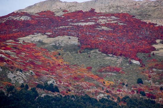
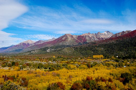
    • The Andean-Patagonian Forest
      The Andean-Patagonian forests, also known as Subantarctic forests, spreads over steep...
    • Ruta 40, North and Cuyo Sectors
      Ruta 40 ("Route 40"), or National Route 40 is the longest and most spectacular road...
    • A Tour to The Marble Chapels
      The "Marble Chapels", in General Carrera Lake, Chile, are mineral formations made...
  • Categories

    Antrophology Birdwatching Books Fauna Fungi Geology History Lakes & Rivers Mountains National Parks Native People Paleontology Plants Route 40 Tours Uncategorized Volcanoes